(below) The blue marker indicates the location of Devil’s Elbow bridge; the red marker points to the former site of a prosperous sawmill owned and operated by the twin brothers Samuel and Silas Stanlake. According to existing education records, the area surrounding their mill was commonly referred to as “Sodom” up until at least the 1930’s.
http://maps.google.ca/maps/ms?hl=en&ie=UTF8&t=h&msa=0&msid=213422929688104395304.00049b68f8f032428ff4c&ll=43.345935,-81.543102&spn=0.021846,0.036478&z=14&output=embed
View Devil’s Elbow in a larger map
(below) North is up on this map. The square block of land featured in the image is bounded today by Dashwood Road (to the north), Ausable Line (to the east), Huron Street (to the south) and Parr Line (to the west). The former site of the Stanlake sawmill is located at the top centre of the image; the former location of the mill itself is indicated by an asterisk, immediately to the west of the Ausable River, adjacent to Dashwood Road. This map, extracted from the H. Belden & Co., 1879 historical atlas of Huron County, indicates apart from Stanlake’s mill, a steady level of development was occurring in the 1870’s at a locale south of the mill in proximity to a series of distinct bends in the Ausable River, near what is locally referred to as “Devil’s Elbow”; to the west of the modern day intersection of Huron Street and Ausable Line. With nearly a dozen structures in place in that immediate vicinity at the time, the budding development appeared well on its way to full village status. None of these buildings survive today. Click on image for a larger version.

“[…] [J]ust west of Concession 5 [Ausable Line], the river makes a loop: two deviations were needed to build a road and bridge the river. This crossing became known as the Devil’s Elbow. There are now few dwellings on this block, but according to the 1879 Huron County Atlas, there were at least seven houses. Some say there was also a cheese factory.”
extracted from “The History of Stephen Township”, by Susan Muriel Mack, 1992; pgs. 222-223
*********************************************
“The first ‘Devil’s Elbow’ bridge was built on the Fourth Sideroad in 1857, by Mr. Balkwill, at a cost of 50 pounds. It was replaced by one built by Mr. Hardy, in 1869, for 370 pounds. The next recorded Devil’s Elbow bridge was built by Joseph Lawson in 1893. This was the last of the wooden bridges to be built over the Ausable in Stephen.”
extracted from “The History of Stephen Township”, by Susan Muriel Mack, 1992; pg. 64
*************************************************
“The same year [1909], council ordered a […] concrete and steel truss bridge on the Fourth Sideroad (the Devil’s Elbow). Contractors Lawson and Hill used the plans prepared for the Crediton East bridge, but made the roadway somewhat narrower. The total cost was $3,409.82” [Ed. note: Approximately $60,000 in today’s funds.]
(below) By the time this photo was taken in 1971, the concrete and steel truss bridge constructed in 1909 was badly depreciating and was eventually replaced in 1981 by an all concrete structure.
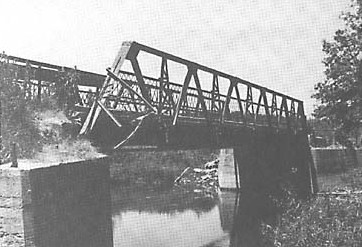
extracted from “The History of Stephen Township”, by Susan Muriel Mack, 1992; pgs. 65-66
*********************************************
“In 1981, Stephen Township council built its third prestressed concrete bridge, to replace the Devil’s Elbow bridge. The approaches to the old bridge were poor: traffic had to turn to get onto the bridge, and then turn again on the other side, and the road was only 13 feet wide.
The new bridge was built about 260 feet west of the old one. Because the river turns to the north, a slight re-alignment of the river bank allowed the road to be straightened. This required a number of land purchases and exchanges and involved the Ausable-Bayfield Conservation Authority, which owns the Hay Swamp, the largest single natural area in the authority’s watershed. The swamp acts as a flood storage and low flow augmentation reservoir for the upper drainage basins of the river. As well, it provides some of the best habitat in Huron County for bass, wood ducks and deer.
The Authority made several requests to ensure that the impact on the wetlands was minimized. As the bridge is located at the lower ends of the wetlands, special care was taken to ensure that the flow of the river was not altered. Council accepted the tender of Elginfield Construction Company Limited for $341,282. The new bridge was 29.88 metres long, the same as the previous one. B.M. Ross and Associates was the engineering company engaged for the project. The total cost of the project was $402,699.
The bridge was finished in August and the official opening ceremonies were held on September 28, 1981.
The inscription on the plaque reads:
Devil’s Elbow Bridge
Township of Stephen
Reeve C.K. Campbell
Deputy Reeve D.C. Russell
Council A.H. Walper
R.E. Weber
T.J. Tomes
Road Superintendent E.L. Finkbeiner
Clerk W.D. Wein
Engineer B.M. Ross and Associates Limited
Contractor Elginfield Construction Limited”
extracted from “The History of Stephen Township”, by Susan Muriel Mack, 1992; pgs. 72-74
*********************************************
[Ed. comment: All areas have their “haunted locales” and southern Huron County is no exception. Both Devil’s Elbow and the nearby former site of the Stanlake brother’s sawmill; also known as “Sodom”, have been cited as locations for purported sightings of an apparition referred to locally as “The Green Lady”. Although variants of the ghostly tale are difficult to trace before the beginning of the 1970s; they persist in the area’s oral tradition, occasionally in the local press, and are now making an appearance on the Internet. In 2010, one creative individual designed a t-shirt based on the figure.]