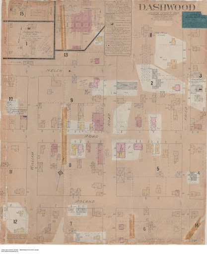
[Ed. Note: The 1896 Chas. E. Goad, Fire Insurance Plan Map of Dashwood shows a wooden structure on this corner labelled as a general store; while the corresponding 1904 map, indicates that the same property is “blank”. Presumably, the John Hall store fire mentioned in the text below occurred sometime between 1896 and 1904. The 1912 Peter McIsaac image clearly indicates a brick structure being erected on the property at that time; although the entranceway layout, located on the corner of the building, is markedly different than what exists today.]
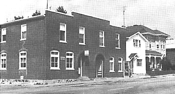
(below) The northeast corner of the intersection of Dashwood Road and Centre Street. Commencing the service in 1941, the ground floor of the left (west) half of this building became one of the many former locations of Dashwood’s post office. The existing building stands on the same site that once contained a store owned by John Hall, which was destroyed by fire. (Rader,pg.7; Muriel Mack pg.184)
View Larger Map
(below) The same structure in September of 1971. The ground floor of the two story white building, immediately to the right (east) of the former post office building block, served as the location of Dashwood’s final telephone switchboards manned by live operators, until dial telephones and automatic switching began in 1966. This building was subsequently converted to rental accommodations and eventually it was torn down.
(Image source: Muriel Mack pg.184)